
Sale!


Modeling And Mapping Topography—Student Activity Kit
Original price was: $46.01.$32.21Current price is: $32.21.
- Experience the Best Quality
- Shop with Confidence, Pay Safely
- Shop quality, shop with us.
- The quality solution for all your needs.

Product Details
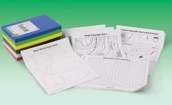
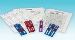
Give students a better sense of direction in three dimensions with this exploration of topography-related concepts. In this three-part activity, students will investigate how elevation and landforms are represented on contour-relief maps.
Kit activities include:
• Identifying common topographic map symbols
• Analyzing a topographic map
• Building a 3-D contour model
Complete for 30 students working in pairs.
Be the first to review “Modeling And Mapping Topography—Student Activity Kit”
Related products
Sale!
Original price was: $38.05.$26.64Current price is: $26.64.
Sale!
Astronomy
Original price was: $91.17.$63.82Current price is: $63.82.
Sale!
Earth & Environmental Science
Original price was: $37.54.$26.28Current price is: $26.28.
Sale!
Earth & Environmental Science
Original price was: $64.06.$44.84Current price is: $44.84.
Sale!

Earth & Environmental Science
Original price was: $56.82.$39.77Current price is: $39.77.
Sale!
Earth & Environmental Science
Original price was: $78.95.$55.27Current price is: $55.27.
Sale!

Original price was: $15.74.$11.02Current price is: $11.02.
Sale!


Earth & Environmental Science
Original price was: $72.90.$51.03Current price is: $51.03.
Reviews
There are no reviews yet.